Whitepapers
![Large city at night with transparent data graphics layered overtop.](https://www.psdcitywide.com/wp-content/uploads/2022/12/GMI-2022-300x169.webp)
Whitepaper: 2022 Geospatial Maturity Index Results and Report
2022 Geospatial Maturity Index Results and Report The 2022 Geospatial Maturity Index (GMI) is the fourth year that PSD Citywide has published its benchmarking study
![Humber Bay Arch Bridge in Toronto, Ontario, Canada.](https://www.psdcitywide.com/wp-content/uploads/2022/12/roads-and-bridges-300x225.webp)
Whitepaper: The State of Ontario’s Roads and Bridges
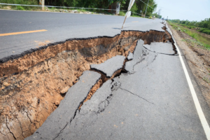
The State of Ontario’s Roads and Bridges Share on Bringing aging capital infrastructure assets to a state of good repair in Ontario’s 444 municipalities undoubtedly
![Collapsed pavement on country road.](https://www.psdcitywide.com/wp-content/uploads/2023/04/integrating-climate-considerations-300x200.png)
Whitepaper: Integrating Climate Considerations into an Asset Management Program
Integrating Climate Considerations into an Asset Management Program Climate change adaptation has become a core pillar underpinning infrastructure resiliency. Precipitation changes, increased temperatures, higher winds,
![Sandbags on flooded area with emergency team in the background pulling a raft with supplies.](https://www.psdcitywide.com/wp-content/uploads/2023/03/using-better-data-300x200.png)
Whitepaper: Using Better Data to Identify Climate Change-Related Infrastructure Vulnerabilities in Canadian Communities
Using Better Data to Identify Climate Change-Related Infrastructure Vulnerabilities in Canadian Communities PSD Citywide, in partnership with CWN, CWWA, and the Federation of Canadian Municipalities
![Modern urban wastewater treatment plant.](https://www.psdcitywide.com/wp-content/uploads/2022/12/leveraging-asset-management-data-300x200.webp)
Whitepaper: Leveraging Asset Management Data for Improved Water Infrastructure Planning
Leveraging Asset Management Data for Improved Water Infrastructure Planning In 2017, Public Sector Digest (PSD Citywide), Canadian Water Network (CWN), and the Canadian Water and
![Elevated view of big city street with high rise buildings on either side.](https://www.psdcitywide.com/wp-content/uploads/2023/03/Geospatial-Maturity-Index-300x200.png)
Whitepaper: Geospatial Maturity Index: Measuring Public Sector Geospatial Program Maturity
Geospatial Maturity Index: Measuring Public Sector Geospatial Program Maturity Share on Measuring Public Sector Geospatial Programs The Geospatial Maturity Index was developed in 2018 to
![Drone view of large residential area.](https://www.psdcitywide.com/wp-content/uploads/2022/12/Open-cities-index-lead-image-300x210.webp)
Whitepaper: Open Cities Index: North America’s Most Open Cities
Open Cities Index: North America’s Most Open Cities Share on Measuring Public Sector Open Data Initiatives PSD launched the Open Cities Index (OCI)—Canada’s first benchmarking
![Wifi icon and city scape and network connection concept.](https://www.psdcitywide.com/wp-content/uploads/2022/12/2020-GMI-300x200.webp)
Whitepaper: 2020 Geospatial Maturity Index Results and Report
2020 Geospatial Maturity Index Results and Report The 2020 Geospatial Maturity Index (GMI) marks the third year that PSD published its benchmarking study for GIS
![Los Angeles, California, USA. Empty freeway streets.](https://www.psdcitywide.com/wp-content/uploads/2022/12/Los-Angeles-300x197.png)
Whitepaper: 2020 Open Cities Index Results and Report
2020 Open Cities Index Results and Report The 2020 Open Cities Index (OCI) marks the fifth year that PSD released its benchmarking study for municipal
![Sunset over Los Angeles downtown.](https://www.psdcitywide.com/wp-content/uploads/2022/12/2019-GMI-lead-image-300x200.webp)
Whitepaper: 2019 Geospatial Maturity Index Results and Report
2019 Geospatial Maturity Index Results and Report In total, the 2019 survey contained 85 questions (compared to 74 from 2018) and had 127 organizations participated.
![View of paved stone road with people walking and cycling in the background.](https://www.psdcitywide.com/wp-content/uploads/2022/12/2019-open-cities-index-main-image-2-300x200.png)
Whitepaper: 2019 Open Cities Index Results and Report
2019 Open Cities Index Results and Report The 2019 Open Cities Index (OCI) is the fourth year that the survey has been released after first
![Light trails on modern buildings in big city at night.](https://www.psdcitywide.com/wp-content/uploads/2022/12/2018-GMI-lead-image-1-300x200.png)
Whitepaper: 2018 Geospatial Maturity Index Results and Report
2018 Geospatial Maturity Index Results and Report Following the success of the Open Cities Index, the first benchmarking program of its kind for municipal open
![View of Downtown Oklahoma City at sunset.](https://www.psdcitywide.com/wp-content/uploads/2022/12/2019-Open-Cities-Index-main-image-300x169.png)
Whitepaper: 2017 Open Cities Index Results and Report
2017 Open Cities Index Results and Report With the publication of the third annual Open Cities Index results, there is a noticeable change in the
![Cars driving on highway with beautiful Autumn coloured trees on either side and city skyline in the horizon.](https://www.psdcitywide.com/wp-content/uploads/2022/12/ontario-infrastructure-300x200.webp)
Whitepaper: The State of Ontario’s Infrastructure – 2016
The State of Ontario’s Infrastructure – 2016 Share on Determining the current state of Ontario’s municipal infrastructure is not a simple task. With non-standardized data