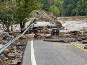
Advisory Services > GIS Advisory Services

GIS Advisory Services

Power your organization with a foundation of accurate spatial data. Our advisory team specializes in the creation, maintenance, and integration of GIS assets, ensuring your internal systems run efficiently to drive smarter decision-making.

Advisory Services > GIS Advisory Services

GIS Advisory Services

Improve your operations with expert GIS services, ensuring accurate and updated asset information for smarter decision making. Further, enhance sustainability and compliance with customized data governance frameworks and tailored mapping solutions.

Take Back Control of Your Asset & GIS Data

Gain control over your asset and GIS data with a team of experts focused on ensuring accuracy, integration, and compliance. 

PSD Citywide provides data validation, regular updates, and system integration alongside GIS solutions like spatial databases, custom mapping, and visualizations tailored to your needs. These services are backed by our team of Asset Management advisors, as well as our Reporting and Compliance practice, supporting informed planning and long-term success.

Digitize Your Critical GIS Data

Our specialists help clients make informed, sustainable decisions by providing services like:

  • Spatial Data Foundation: Creation of spatial databases to support municipal planning, utilities, and permitting. This includes the integration of data into systems like CMMS, work orders, financial/ERP tools, and permitting platforms
  • Mapping & Analysis: Spatial data digitization for infrastructure, zoning, and environmental datasets. We also offer environmental impact and climate analysis, supporting natural asset inventories and flood mapping

What We Deliver

Accurate and Current Data

Validated and regularly updated asset and spatial data, including maintenance of accurate parcel data for taxation and zoning

Integrated Systems

Seamless data flow between GIS and municipal systems (CMMS, financial/ERP, permitting)

Custom Mapping & Visualization

Tailored maps for council presentations, public engagement, and community reporting

Expert Support & Training

Hands-on, role-based training to ensure staff can confidently navigate and use the municipal geospatial environment

Why It Matters

Smarter Decisions

Accurate spatial data enables more informed, efficient, and transparent decisions for better service delivery and planning

Operational Efficiency

Integration eliminates duplicate entry and outdated datasets, reducing complexity

Risk Mitigation

Enhanced compliance and better data quality minimize regulatory risk and errors

Sustainability

Environmental mapping and climate analysis support municipal climate adaptation planning

Long-Term Success

Stable data governance and coordinated planning lead to a higher return on your investment

Efficiency Through Data Integration: North Huron’s GIS Upgrade

We empower small to mid-sized municipalities to modernize legacy systems and achieve true data accuracy. Our proven methods, including data cleanup, validation, and schema design, delivers improved data quality and successful GIS integrations.

See how municipalities like the Township of North Huron have achieved better data quality and enhanced asset management through our GIS services and integration with the Citywide Platform.

Ready to Improve Your Spatial Data?

Take the first step toward integrated, accurate, and compliant GIS data. Speak with one of our GIS Advisors today to discuss your GIS and digitization challenges and how we can help.

Related Articles